
This page will be active with updates during a Hurricane or Major Storm with local impacts to Baldwin County, AL.
EMA - Baldwin County Updates
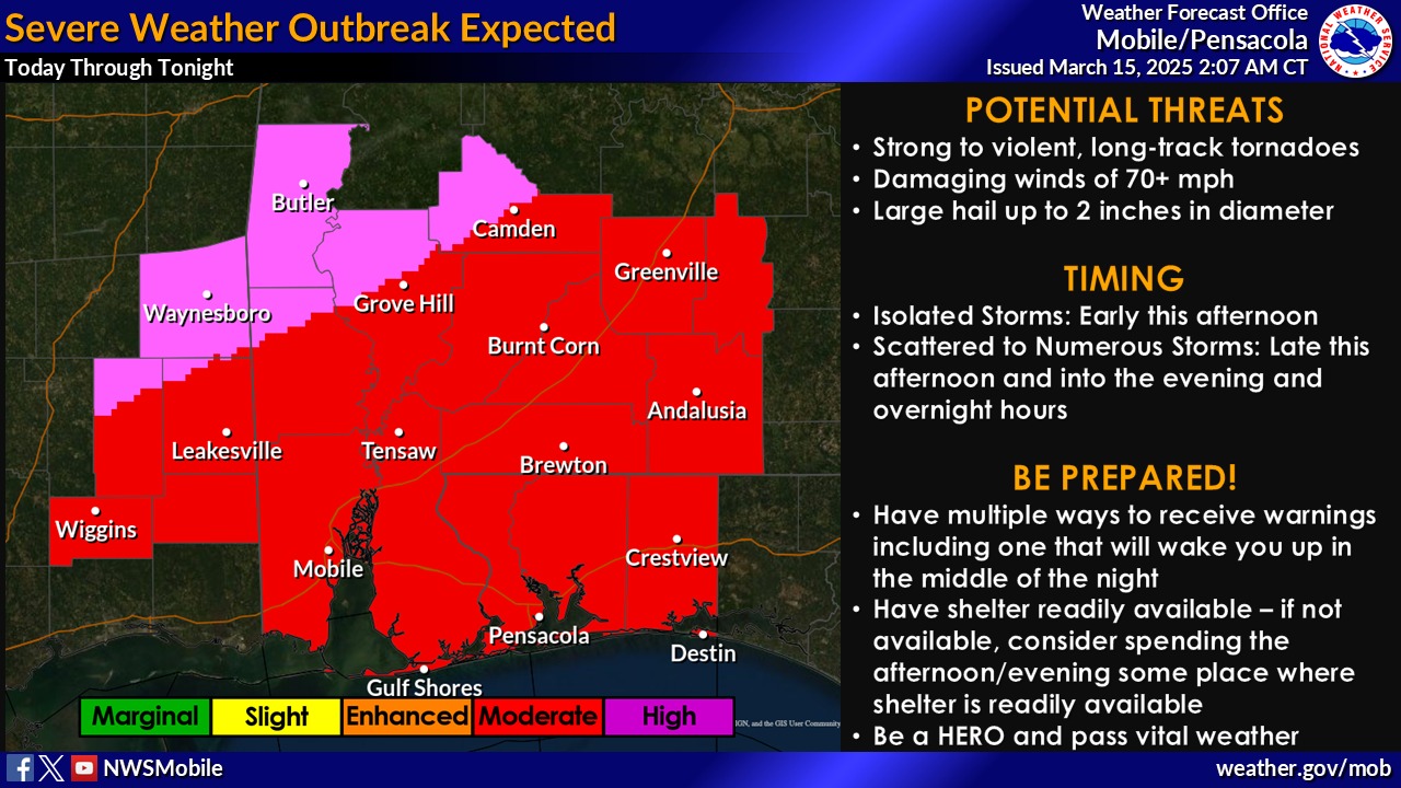
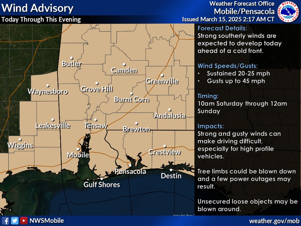
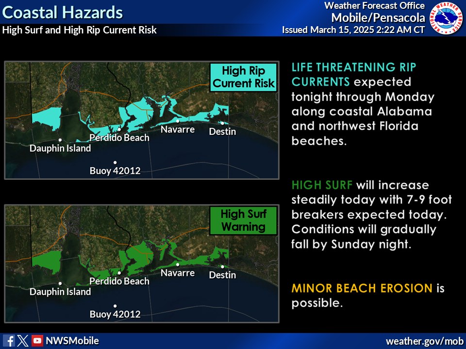
3/15/25 5:40 am update from National Weather Service:
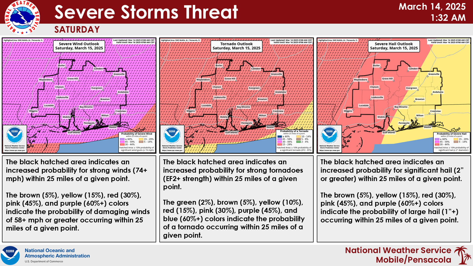
Overview: A Severe Thunderstorm and Tornado outbreak is likely today into tonight across much of the region. There will be a relatively calm period this morning, but don't let this fool you as scattered to possibly numerous thunderstorms are expected to develop and move east across the area during the afternoon and evening hours. The environment will be very supportive of a likely severe outbreak. Long track, significant to violent tornadoes, large hail to 2 inches in diameter, and damaging wind gusts over 70 mph will be possible in any storms that develop.
Severe Storms: Currently, our northwestern zones are outlooked in a High Risk [Level 5 of 5] for severe weather, while the remainder of the area is in a Moderate Risk [Level 4 of 5]. Please DO NOT focus on where the highest risk area is located. Our entire local area will be primed for significant severe weather so do not let your guard down if you are located outside the highest risk area! Be sure to have multiple ways to receive warnings. Storms should diminish from west to east during the overnight hours Saturday into early Sunday morning.
Non-thunderstorm winds: Outside of thunderstorms, it will be quite windy across the area. Over land, a Wind Advisory is in effect from 10am today Saturday through 12am Sunday across the entire local area. Sustained winds of around 20-25 mph, with gusts to around 45 mph can be expected.
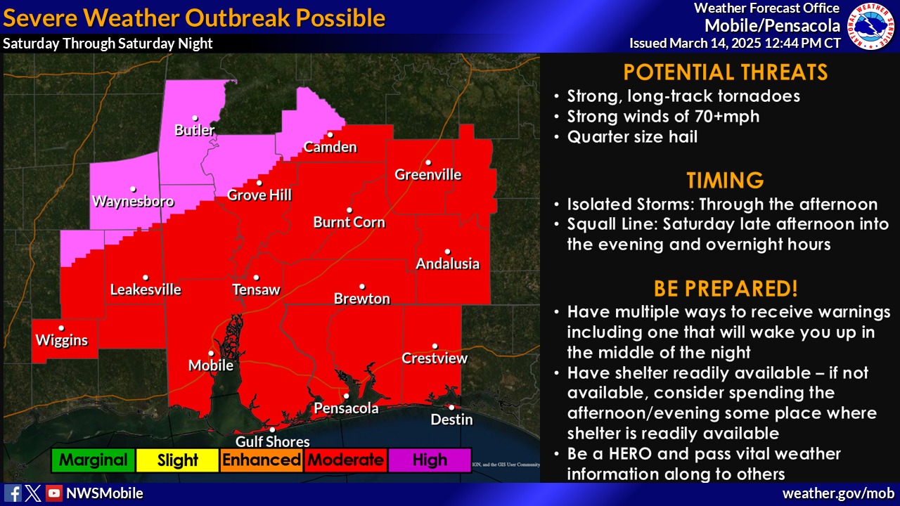
Updates from National Weather Service Mobile:
- Multiple rounds of severe storms are expected today through Saturday
- The main event is Saturday with isolated storms expected to ramp up starting as early as the late morning hours and persisting into the afternoon, followed by a squall line that sweeps across the region late in the afternoon and into the night
- Strong southerly winds will lead to numerous coastal concerns (High Risk of Rip Currents, High Surf, Coastal Flooding) along with gale conditions over the Gulf waters
Safer Places to Open in Baldwin County:
St. Paul’s Episcopal Church in Foley (506 N Pine St, Foley, AL 36535) will be opening their doors tomorrow, Sat, March 15 from 10:00 a.m. until Sun. March 16 at 6:00 a.m. Citizens are asked to come self-sufficient with bedding, toiletries, medications and food. Cots and blankets will be provided on a first come/first serve basis. No drugs or alcohol will be permitted and citizens will be asked to leave should these items be found.
Another Safer Place Opening in Baldwin County:
Update from National Weather Service of Mobile:
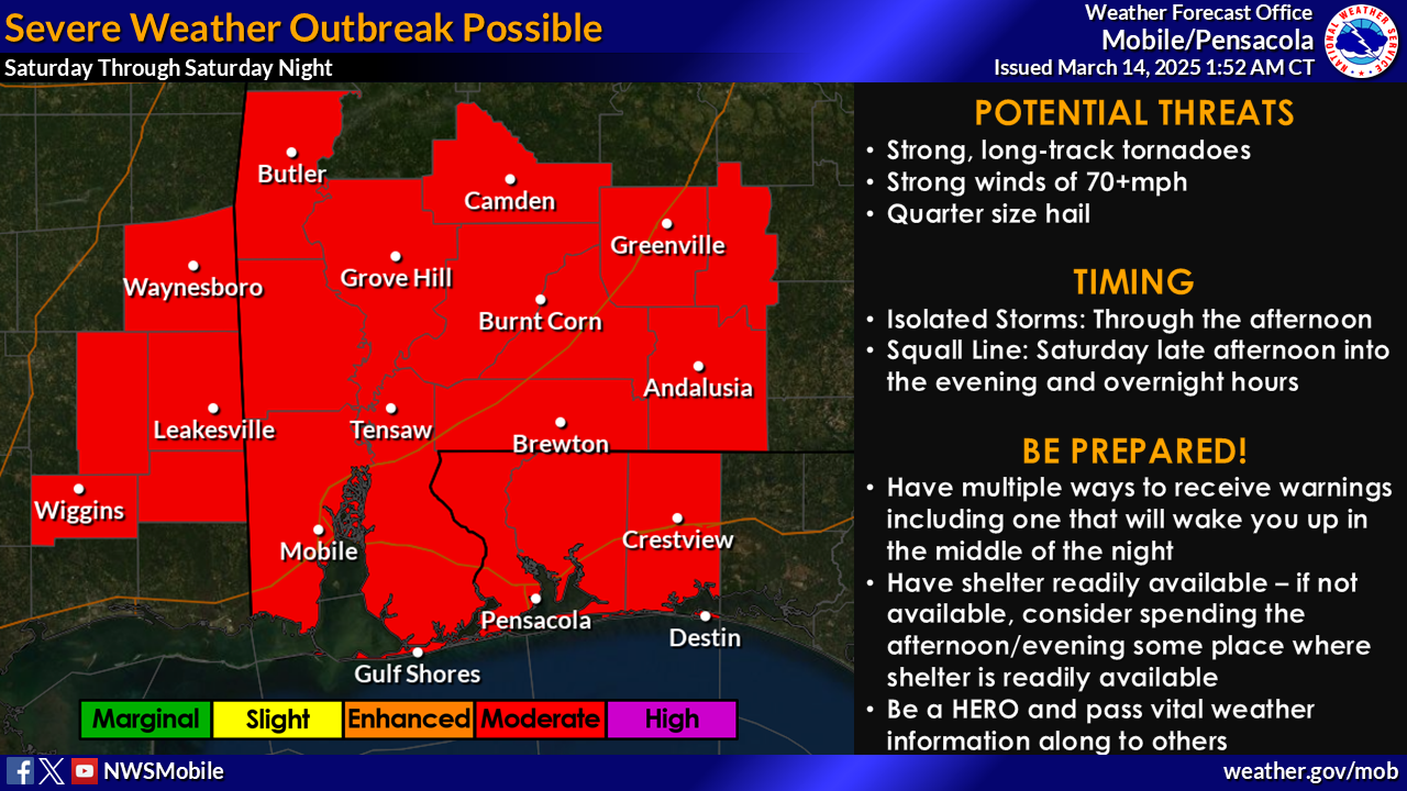
"*A regional outbreak of severe storms is expected Saturday afternoon through Saturday night across the entire area. The MODERATE risk has been expanded eastward.*
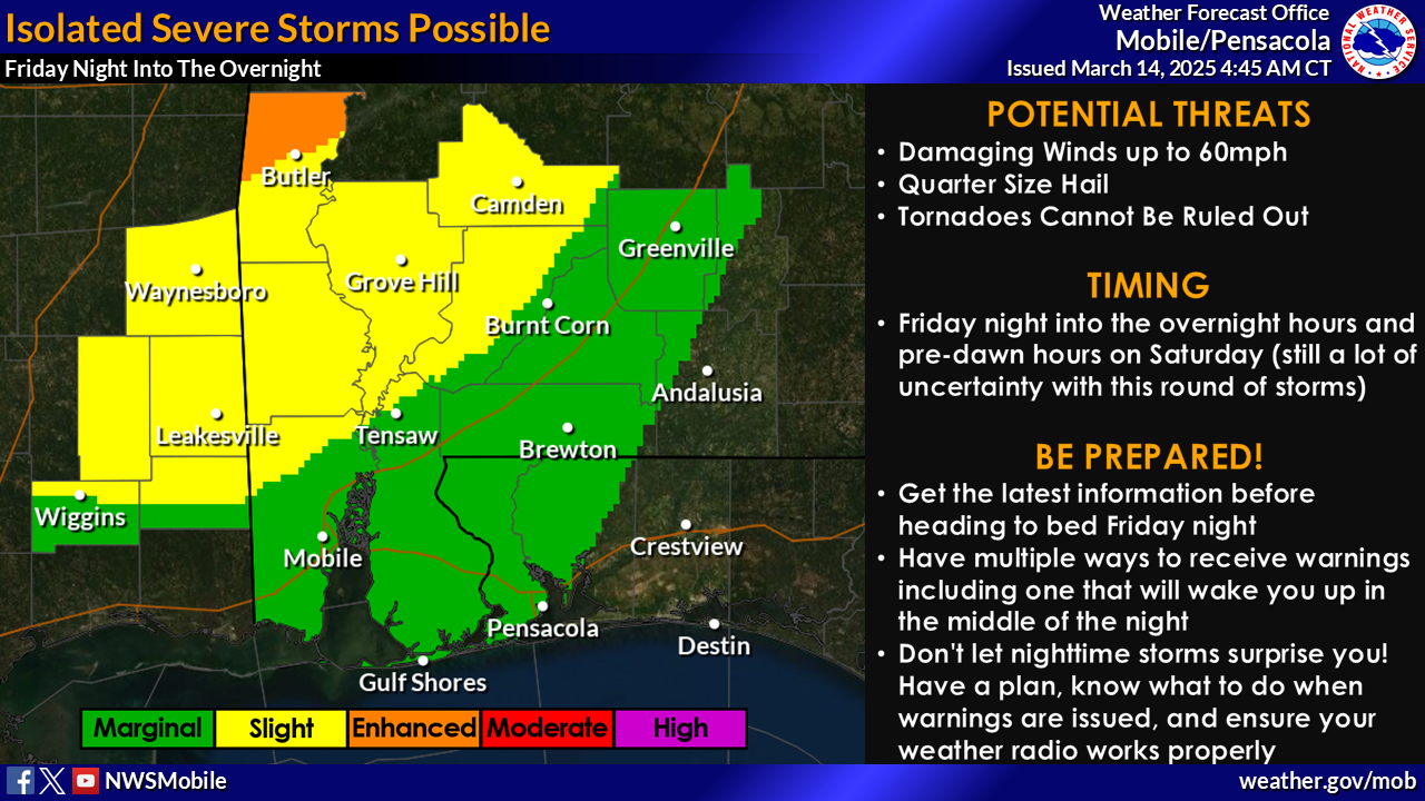
IMPACT #1 - Severe Storms Possible Tonight
WHAT: Isolated severe thunderstorms may develop and be capable of producing damaging winds and large hail. A tornado or two cannot be ruled out.
WHEN: Between 10 PM Friday and 6 AM Saturday
WHERE: Areas west of I-65, with the best potential for severe storms north of Highway 84 in southwest Alabama and southeast Mississippi.
CONFIDENCE: Confidence is low on the severe threat Friday night.
WHAT WE ARE WATCHING: The strength of the forcing over the areas is very uncertain. If there is enough forcing for thunderstorms, they will have the potential to become severe quickly.
IMPACT #2 - Severe Thunderstorms Likely on Saturday
WHAT: Isolated supercells will develop late Saturday morning through the afternoon ahead of a squall line that will swing across the area from west to east. Strong long-track tornadoes, strong winds, and large hail are all possible.
WHEN: Isolated storms during the afternoon, with a line of storms moving through during the late afternoon Saturday through early morning hours on Sunday.
WHERE: The entire area.
CONFIDENCE: Confidence is high that there will be numerous severe storms on Saturday.
WHAT WE ARE WATCHING: The timing and coverage of thunderstorms Friday night into Saturday morning will impact the severe potential later in the day. If storms don't develop or end before sunrise, the environment will support significant severe thunderstorms during the afternoon and evening (most likely scenario). If storms develop and linger on Saturday morning, this could contaminate the environment leading into Saturday, limiting the severity of storms (less likely scenario)."
Please see graphic for more information.
A Message from Baldwin County Emergency Management Agency:
For Your Awareness:
- Sand is available: located at the Baldwin County Central Annex (22251 Palmer St. Robertsdale, AL 36567). This is "self-serve". Please bring your own bags and tools if you need sand.
Preparedness Tips:
- Have multiple ways of receiving correct information from National Weather Service of Mobile, Baldwin County EMA,, a NOAA weather radio, and your local news outlets.
- Sign up for local, emergency alerts through www.alertbaldwin.com/.
- Know your risks and potential impacts. Know your location on a map.
- Have any necessary supplies gathered to be self-sufficient for 5 days. Don’t forget medications and pet supplies.
- Review important documents and insurance policies. Make sure you have flood insurance if needed.
- Make an emergency plan and ensure all family members know how to contact each other.
- Steer clear of misinformation (especially on social media). Have multiple forms of receiving CORRECT information. (Baldwin County EMA, National Weather Service of Mobile, Local media outlets, etc.)
- Monitor daily beach conditions and be aware of flag warnings. For a daily beach report, text ALBEACHES to 888777.
For more information on emergency preparedness: https://baldwincountyal.gov/ema
For any media inquiries: https://baldwincountyal.gov/departments/county-administration/media-request
BCEMA and local officials are monitoring conditions and will update as any new information becomes available through National Weather Service of Mobile.
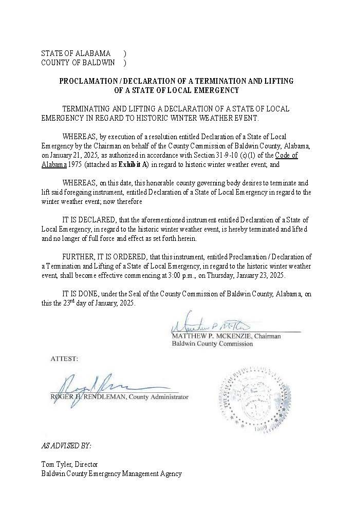
As of 3:00 PM on January 23, 2025, the Baldwin County Commission has officially lifted the current State of Local Emergency.
Additionally, the “Impassable Roads Advisory” has now lifted. While weather conditions are improving, freezing temperatures are expected tonight and into the early morning hours. Baldwin County EMA advises residents to use EXTREME CAUTION when traveling. Icy patches may persist on shaded roads, bridges, and overpasses, particularly during the early hours.
• Avoid sudden braking or sharp turns to maintain control of your vehicle.
The Baldwin County Commission has also announced that all county-maintained facilities, including courthouses, will reopen on Friday, January 24th, during normal operating hours.
The Baldwin County Commission continues to monitor and respond to the ongoing winter weather conditions impacting the region. As one of the largest counties in the state, Baldwin County is experiencing widespread impacts across its extensive area, and officials are urging residents to stay vigilant and take necessary precautions.
Warming Shelter Updates
Warming shelters across Baldwin County remain open to provide safe and warm spaces for residents and visitors. Latest reported shelter occupancy numbers include:
- St. Paul’s Episcopal Church (Foley): 12
- Fairhope United Methodist Church: 2
- Robertsdale First Baptist Church: 0
- Restoration House of Atmore: 15
Baldwin County 9-1-1
Baldwin County 9-1-1 has reported a high volume of calls due to the hazardous road conditions. To minimize accidents and ensure emergency response availability, the public is strongly urged to stay off the roads.
Road Conditions
Baldwin County remains under an Impassable Roads Advisory.
The Baldwin County Highway Department is actively patrolling roads and assessing safety. Due to the size of Baldwin County, these widespread impacts are being felt across multiple areas, with some regions experiencing greater challenges in accessibility. Travel is strongly discouraged unless absolutely necessary.
Utilities
Utility companies are continuing to request that residents and businesses conserve power. Despite the challenging weather, crews are working diligently to restore power and make necessary repairs as quickly as possible.
Baldwin County Commission Closures
Due to the continuing winter weather conditions, the Baldwin County Commission has determined that all county-maintained facilities, including courthouses, will remain closed on Thursday, January 23rd.
Baldwin County Public Schools
Baldwin County Public Schools are now closed Thursday, January 23rd and Friday, January 24th Residents are encouraged to stay tuned to school district updates for the latest information.
Stay Informed
For the latest updates on road conditions, warming shelter availability, and other safety information, follow Baldwin County EMA on social media or visit www.BaldwinCountyEMA.com.
Due to the continuing winter weather conditions, the Baldwin County Commission has determined that all county-maintained facilities, including courthouses, will remain closed on Thursday, January 23rd.
Again, residents and visitors are strongly encouraged to avoid travel during this time. Icy conditions, particularly on bridges and overpasses, can make travel hazardous and should be avoided, if possible, to ensure safety.
The Baldwin County Commission continues to monitor and respond to the ongoing winter weather conditions impacting the region. As one of the largest counties in the state, Baldwin County is experiencing widespread impacts across its extensive area, and officials are urging residents to stay vigilant and take necessary precautions.
Warming Shelter Updates
Warming shelters across Baldwin County remain open to provide safe and warm spaces for residents and visitors. Latest reported shelter occupancy numbers include:
- St. Paul’s Episcopal Church (Foley): 10
- Fairhope United Methodist Church: 1
- Robertsdale First Baptist Church: 0
- Restoration House of Atmore: 15
Baldwin County 9-1-1
Baldwin County 9-1-1 has reported a high volume of calls due to the hazardous road conditions. To minimize accidents and ensure emergency response availability, the public is strongly urged to stay off the roads.
Road Conditions
Baldwin County remains under an Impassable Roads Advisory.
The Baldwin County Highway Department is actively patrolling roads and assessing safety. Due to the size of Baldwin County, these widespread impacts are being felt across multiple areas, with some regions experiencing greater challenges in accessibility. Travel is strongly discouraged unless absolutely necessary.
Utilities
Utility companies are continuing to request that residents and businesses conserve power. Despite the challenging weather, crews are working diligently to restore power and make necessary repairs as quickly as possible.
Baldwin County Public Schools
Baldwin County Public Schools are closed for the remainder of the week. Schools will open for Monday, January 27th, with regular schedule. Residents are encouraged to stay tuned to school district updates for the latest information.
Stay Informed
For the latest updates on road conditions, warming shelter availability, and other safety information, follow Baldwin County EMA on social media or visit www.BaldwinCountyEMA.com.
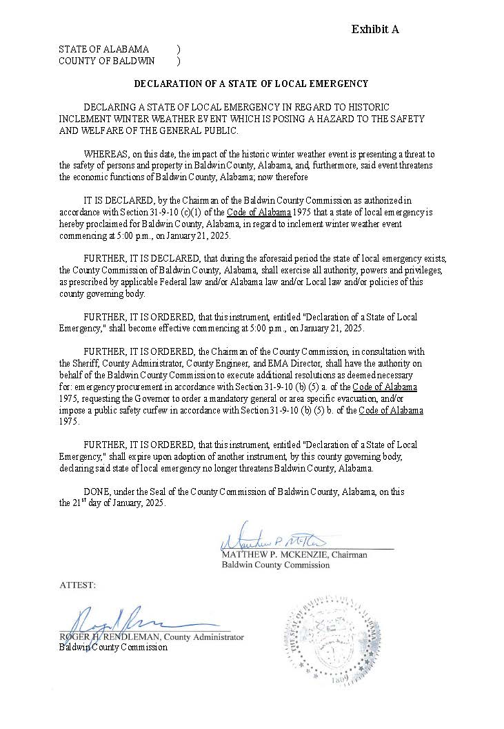
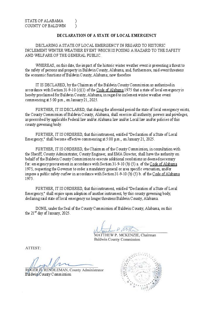
The Baldwin County Commission has declared a Local State of Emergency in response to the ongoing historic inclement winter weather conditions affecting the area. This declaration allows Baldwin County to access additional resources and coordinate more effectively with state and local partners to address the impacts of the severe weather.
The Local State of Emergency reinforces the importance of public safety and supports efforts to manage icy road conditions, provide warming shelters, and ensure the well-being of residents and visitors.
For the further updates on road conditions, shelter availability, and other safety information, follow Baldwin County EMA on social media or visit www.BaldwinCountyAL.gov/EMA
As of 12 p.m. on January 21, 2025, all roads and bridges in Baldwin County should be considered IMPASSABLE until further notice due to severe winter weather conditions.
Members of the general public are advised to suspend or delay all travel. Only emergency vehicles should attempt to travel on county roads and bridges during this time to ensure public safety and to allow crews to respond to weather-related hazards effectively.
Baldwin County Emergency Management Agency (EMA), in partnership with Voluntary Organizations Active in Disaster (VOAD), is sharing updated information about warming shelters available for residents and visitors during this winter weather event.
The following warming shelters are open to the public:
- St. Paul’s Episcopal Church 506 N. Pine St., Foley, AL 36536 Open: Sunday, January 19th at 5:00 PM through Thursday, January 23rd at 3:00 PM
- Fairhope United Methodist Church 155 S. Section St., Fairhope, AL 36532 Open nightly: Monday, January 20th through Tuesday, January 21st at 7:00 AM / Tuesday, January 21st at 9:00 PM through Wednesday, January 22nd at 8:00 AM / Wednesday, January 22nd at 9:00 PM through Thursday, January 23rd at 7:00 AM / Friday, January 24th until 3:00 PM / **FUMC will stay open during the day on Tuesday & Wednesday as needed
- St. Paul's Episcopal Church 28788 N Main St, Daphne, AL 36526 CLOSED at the time.
- Robertsdale First Baptist Church 18200 AL-104 Robertsdale, AL 36526 Open: Monday, January 20th from 5:00 PM through Wednesday, January 22nd at 9:00 AM . Wednesday, January 22nd from 5:00 PM through 9:00 AM / Thursday, January 23rd at 10:00 AM through Friday, January 24th at 9:00 AM
- Restoration House of Atmore 1010 East Nashville Ave. Atmore, AL 36502 Open: 24 Hours a Day
Please be aware that these locations, dates, and times are subject to change. Updates will be posted on the Baldwin County EMA Facebook and Instagram page as well as sent out to media partners.
Thursday, January 23 routes will operate as normal, and landfills and offices will reopen. Garbage routes scheduled for Tuesday, January 21 will be picked up on Friday, January 24, and those scheduled for Wednesday, January 22 will be picked up on Saturday, January 25.
In preparation for the upcoming winter weather, the Baldwin County Commission will close all county-maintained facilities, including courthouses, on Tuesday, January 21st, through Wednesday, January 22nd. Facilities are expected to reopen during their regular business hours on Thursday, January 23rd, pending weather conditions.
Additionally, the regularly scheduled Baldwin County Commission meeting on Tuesday, January 21st, has been rescheduled to the following week, on Tuesday, January 28th located at the Fairhope Satellite Courthouse.
Residents and visitors are strongly encouraged to avoid travel during this time. Icy conditions, particularly on bridges and overpasses, can make travel hazardous and should be avoided if possible to ensure safety.
The Baldwin County Commission Highway Department is actively monitoring road conditions and will deploy sand as needed to address icy areas and improve safety.
The shelter, located at 506 N. Pine St., Foley, AL 36536, will open on Sunday, January 19th at 5:00 PM and remain available through Wednesday, January 22nd at 12:00 PM. Anyone needing to contact the Safer Place for any reason can call 251-256-8202.
Individuals seeking shelter are encouraged to bring essential items, such as blankets, pillows, personal medications, and any other necessities for their stay.
Baldwin County EMA has worked in coordination with Voluntary Organizations Active in Disaster (VOAD) to ensure resources and support are in place for an effective community response during this event.
As winter weather is unusual in Baldwin County, residents and visitors are encouraged to take the following precautions:
If you must drive on the roadways, please be cautious and heed the following safe winter weather driving tips:
- Decrease your speed and leave yourself plenty of room to stop.
- Brake gently to avoid skidding. If your wheels start to lock up, ease off the brake.
- Turn your lights on for increased visibility.
- Don’t use cruise control or overdrive on ice roads.
This is the last planned update from our local National Weather Service.
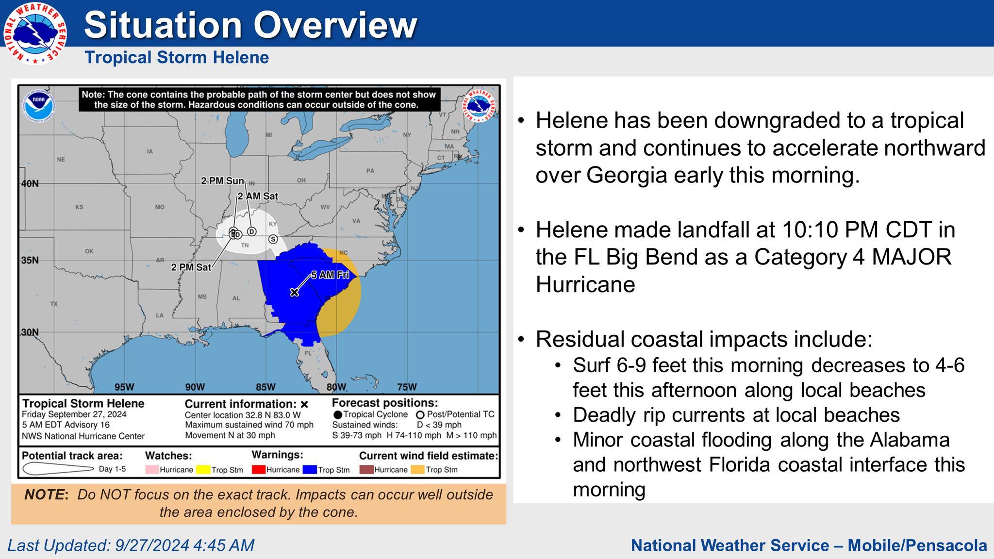
Helene continues to accelerate northward across Georgia early this morning and is now a Tropical Storm. Residual coastal impacts will continue with:
1) Deadly rip currents along the Alabama beaches today and tonight and along the western Florida panhandle beaches through Saturday afternoon
2) Dangerous high surf with breakers of 6-9 feet persisting along area beaches this morning, subsiding to 4-6 feet this afternoon
3) Minor coastal flooding along the Alabama and western Florida panhandle coastal interface as we head into high tide early this morning. Dry weather conditions are otherwise expected for the next several days.
For Your Awareness:
- Beach Flags have now upgraded to Double Red.
A Message to Potential Volunteers:
Do Not Self- Deploy. Coordinate through VOAD (Voluntary Organizations Active in Disaster)
Once assigned a position, make sure you have been given an assignment and are wearing proper safety gear for the task. Be patient. Recovery lasts a lot longer than the media’s attention. There will be volunteer needs for many months, often years, after the disaster, especially when the community enters the long-term recovery period."
Join Baldwin County VOAD: https://baldwincountyal.gov/ema/voad
For more information on emergency preparedness: https://baldwincountyal.gov/ema
For any media inquiries: https://baldwincountyal.gov/departments/county-administration/media-request
• Hurricane Helene is now a MAJOR HURRICANE with maximum sustained winds of 130 mph (Category 4) and will continue to strengthen as it lifts north northeast across the Gulf of Mexico
• Comparing the system with previous hurricanes in the Gulf over the past couple of decades, Helene is at the upper bound in terms of size…and, as a result, storm surge, wind, and rainfall impacts will extend far away from the center and well outside the forecast cone, particularly on the east side.
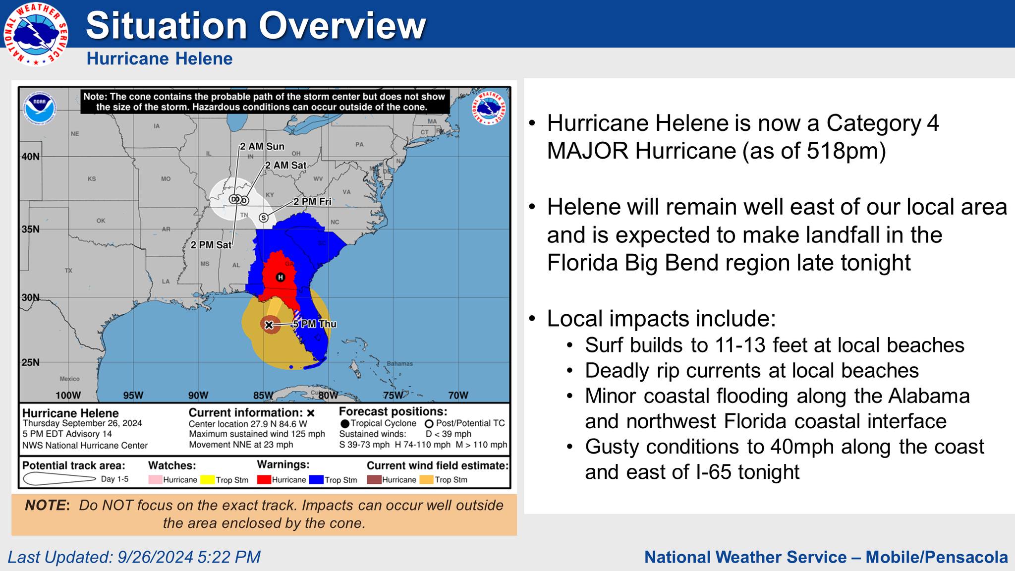
Hurricane Helene is now a Category 4 MAJOR Hurricane (as of 518pm)
• Hurricane Helene is expected to remain well east of our local area and is expected to make landfall in the Florida Big Bend region late tonight
Local impacts include:
• Gusty conditions along the coast and east of I 65 gusts to 40 mph possible)
Tropical Related Watches and Warnings:
• Northerly winds will increase to 15 to 25 mph with gusts up to 40 mph possible in the Wind Advisory
Potential Impacts:
• Likely time for 40mph gusts along the coast: Now through roughly 2am
• Likely time for 40mph gusts in south central Alabama: Ramping up before midnight through 4am
High Risk of deadly rip currents:
• When: Through Friday Night.
Dangerously High Surf:
– Breakers greater than 11-13 feet expected this evening through early Friday morning
Coastal Flood Advisory:
• When Through early Friday afternoon
– Inundation of 2.0 2.5 feet MHHW in northwest Florida and 2.0 feet along coastal Alabama
- Note: Water levels drop tonight with low tide and northerly winds with a quick rebound in the pre dawn hours on Friday
• Up to 2 inches of rain is forecast across far eastern portions of our area (south central Alabama and northwest Florida)
• Locally heavy rainfall in a short period of time could result in localized flooding of urban and low lying areas.
Key Take-Aways:
For Your Awareness:
- Sand is available: located at the Baldwin County Central Annex (22251 Palmer St. Robertsdale, AL 36567). This is "self-serve". Please bring your own bags and tools if you need sand.
- Beach Flags have now upgraded to Double Red.
Preparedness Tips:
- Have multiple ways of receiving correct information from National Weather Service of Mobile, Baldwin County EMA, and your local news outlets.
- Sign up for local, emergency alerts through www.alertbaldwin.com/.
- Know your risks and potential impacts. Know your location on a map, your evacuation zone and potential evacuation routes.
- Have any necessary supplies gathered to be self-sufficient for 5 days. Don’t forget medications and pet supplies.
- Review important documents and insurance policies. Make sure you have flood insurance if needed.
- Make an emergency plan and ensure all family members know how to contact each other and where to meet in case of an evacuation.
- Steer clear of misinformation (especially on social media). Have multiple forms of receiving CORRECT information. (Baldwin County EMA, National Weather Service of Mobile, Local media outlets, etc.)
- Monitor daily beach conditions and be aware of flag warnings. For a daily beach report, text ALBEACHES to 888777.
For more information on emergency preparedness: https://baldwincountyal.gov/ema
For any media inquiries: https://baldwincountyal.gov/departments/county-administration/media-request
BCEMA and local officials are monitoring conditions and will update as any new information becomes available through National Weather Service of Mobile.
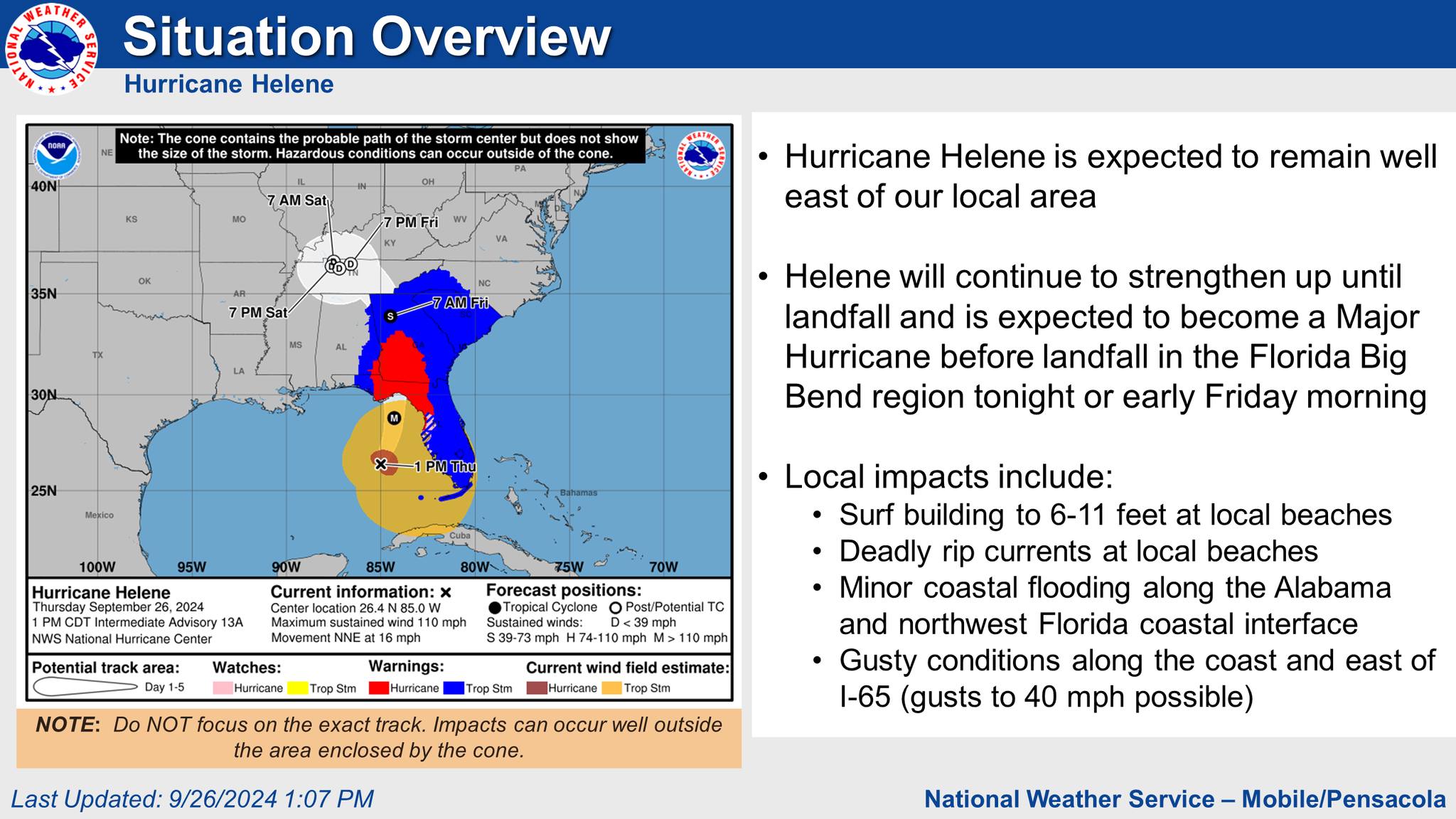
No significant changes occurred overnight there will continue to be wobbles in the track, but no major shifts are expected.
• Hurricane Helene is a Category 2 Hurricane this morning and will continue to strengthen as it lifts north northeast across the eastern Gulf of Mexico.
• Helene will continue to accelerate later today in the flow between a ridge over the Atlantic and trough over the Tennessee Valley.
• Comparing the system with previous hurricanes in the Gulf over the past couple of decades, Helene is at the upper bound in terms of size…and, as a result, storm surge, wind, and rainfall impacts will extend far away from the center and well outside the forecast cone, particularly on the east side.
• Hurricane Helene is expected to remain well east of our local area.
• Helene will continue to strengthen up until landfall and is expected to become a Major Hurricane before landfall in the Florida Big Bend region tonight or early Friday morning
• Gusty conditions along the coast and east of I 65 gusts to 40 mph possible)
Tropical Related Watches and Warnings:
• Northerly winds will increase to 15 to 25 mph with gusts up to 40 mph possible in the Wind Advisory
Potential Impacts:
• There is still a 2 to 3 in 10 chance of tropical storm force winds sustained winds of 39+ mph) across the far eastern portions of south central Alabama and northwest Florida
• Likely time of stronger gusts (30 40mph) along the coast: Ramping up around 2 3pm and lasting until midnight
• Probabilities of 40mph wind gusts along the coast begin to increase around 7pm this evening
• Based on the latest track and guidance, the probability for storm surge inundation west of the Walton/Bay County Line is very low
• Locally, water levels will drop tonight with low tide and northerly winds with a quick rebound to coastal flood inundation levels in the pre dawn hours on Friday
High Risk of deadly rip currents:
• When: Through Friday Night.
Dangerously High Surf:
– Breakers greater than 10 feet expected this evening through late tonight.
Coastal Flood Advisory:
• When Through early Friday afternoon, especially with high tide early Friday.
– Inundation of 2.0 2.5 feet
• The rainfall forecast has decreased slightly since yesterday with a sharp gradient expected on the west side of the storm
• Up to 2 inches of rain is forecast across far eastern portions of our area (south central Alabama and northwest Florida)
• Locally heavy rainfall in a short period of time could result in localized flooding of urban and low lying areas.
Key Take-Aways:
• Wind gusts up to 40 mph are possible across portions of south central Alabama, northwest Florida, and far southwest Alabama starting this afternoon and persisting through the evening hours.
For Your Awareness:
- Sand is available: located at the Baldwin County Central Annex (22251 Palmer St. Robertsdale, AL 36567). This is "self-serve". Please bring your own bags and tools if you need sand.
- Beach Flags have now upgraded to Double Red.
Preparedness Tips:
- Have multiple ways of receiving correct information from National Weather Service of Mobile, Baldwin County EMA, and your local news outlets.
- Sign up for local, emergency alerts through www.alertbaldwin.com/.
- Know your risks and potential impacts. Know your location on a map, your evacuation zone and potential evacuation routes.
- Have any necessary supplies gathered to be self-sufficient for 5 days. Don’t forget medications and pet supplies.
- Review important documents and insurance policies. Make sure you have flood insurance if needed.
- Make an emergency plan and ensure all family members know how to contact each other and where to meet in case of an evacuation.
- Steer clear of misinformation (especially on social media). Have multiple forms of receiving CORRECT information. (Baldwin County EMA, National Weather Service of Mobile, Local media outlets, etc.)
- Monitor daily beach conditions and be aware of flag warnings. For a daily beach report, text ALBEACHES to 888777.
For more information on emergency preparedness: https://baldwincountyal.gov/ema
For any media inquiries: https://baldwincountyal.gov/departments/county-administration/media-request
BCEMA and local officials are monitoring conditions and will update as any new information becomes available through National Weather Service of Mobile.
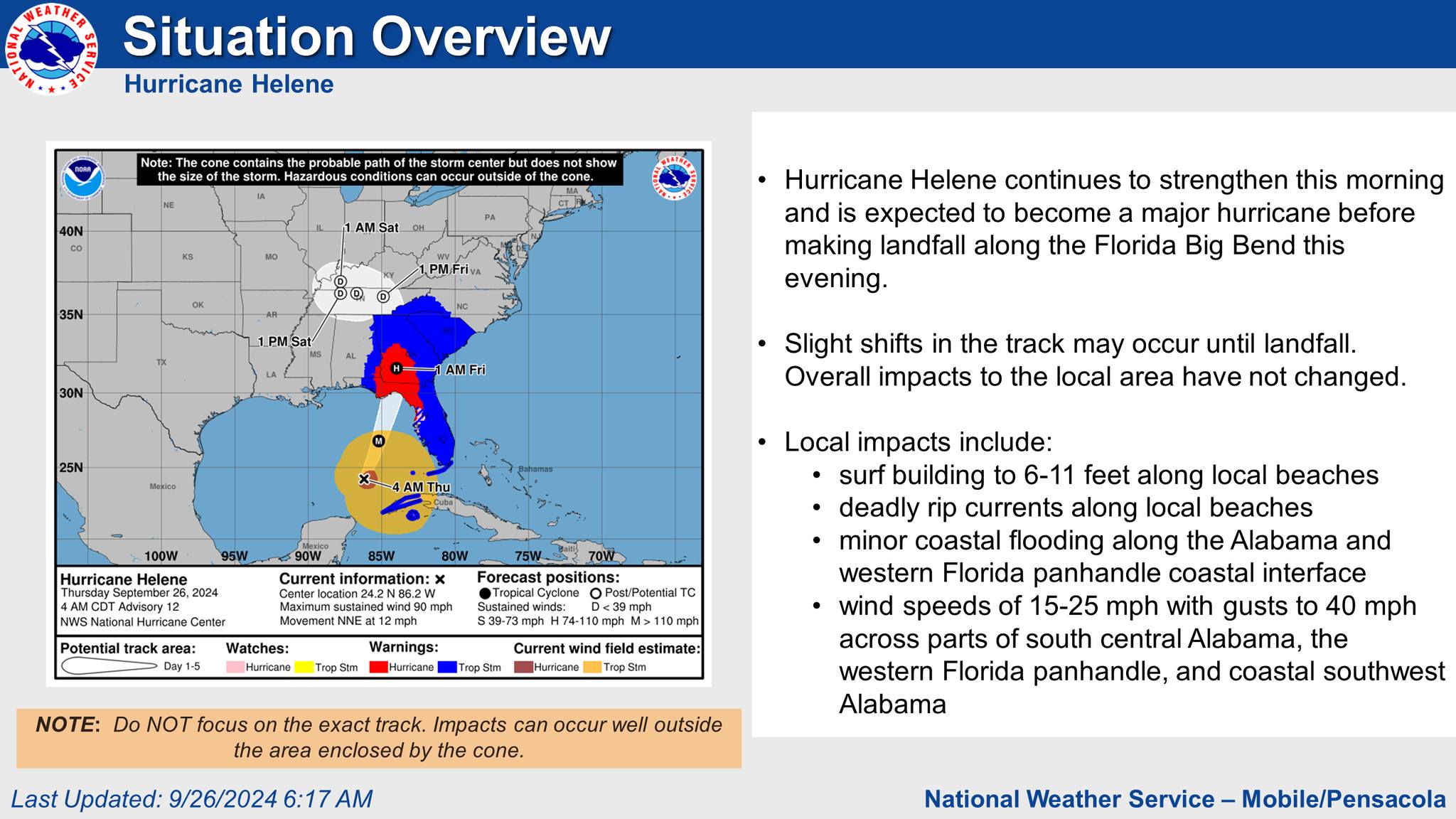
• Hurricane Helene continues to strengthen this morning and is expected to become a major hurricane before making landfall along the Florida Big Bend this evening
• Slight shifts in the track may occur until landfall . Overall impacts to the local area have not changed
• Wind speeds of 15 25 mph with gusts to 40 mph across parts of south central Alabama, the western Florida panhandle, and coastal southwest Alabama
Based on the latest track and guidance, the probability for storm surge inundation west of Mexico Beach is very low.
Potential Impacts:
- Tropical storm force (>=39 mph) wind speed probabilities are similar to the previous advisory.
- There is a 1 in 10 to 2 in 10 chance of tropical storm force winds across portions of south central Alabama and northwest Florida.
- Northerly winds will increase to 15 to 25 mph with gusts up to 40 mph possible across far southwest Alabama, the western Florida panhandle, and interior south central Alabama.
High Risk of deadly rip currents:
• When: Through Friday Night.
Dangerously High Surf:
– Breakers greater than 10 feet expected this evening through late tonight.
Coastal Flood Advisory:
• When This morning through early Friday morning.
• The rainfall forecast has decreased slightly. Up to 2 inches of rain is now forecast across far eastern portions of our area in south central Alabama and the western Florida panhandle.
• Locally heavy rainfall in a short period of time could result in localized flooding of urban and low lying areas.
Key Take-Aways:
For Your Awareness:
- Sand is available: located at the Baldwin County Central Annex (22251 Palmer St. Robertsdale, AL 36567). This is "self-serve". Please bring your own bags and tools if you need sand.
- Beach Flags have now upgraded to Single Red.
Preparedness Tips:
- Have multiple ways of receiving correct information from National Weather Service of Mobile, Baldwin County EMA, and your local news outlets.
- Sign up for local, emergency alerts through www.alertbaldwin.com/.
- Know your risks and potential impacts. Know your location on a map, your evacuation zone and potential evacuation routes.
- Have any necessary supplies gathered to be self-sufficient for 5 days. Don’t forget medications and pet supplies.
- Review important documents and insurance policies. Make sure you have flood insurance if needed.
- Make an emergency plan and ensure all family members know how to contact each other and where to meet in case of an evacuation.
- Steer clear of misinformation (especially on social media). Have multiple forms of receiving CORRECT information. (Baldwin County EMA, National Weather Service of Mobile, Local media outlets, etc.)
- Monitor daily beach conditions and be aware of flag warnings. For a daily beach report, text ALBEACHES to 888777.
For more information on emergency preparedness: https://baldwincountyal.gov/ema
For any media inquiries: https://baldwincountyal.gov/departments/county-administration/media-request
BCEMA and local officials are monitoring conditions and will update as any new information becomes available through National Weather Service of Mobile.
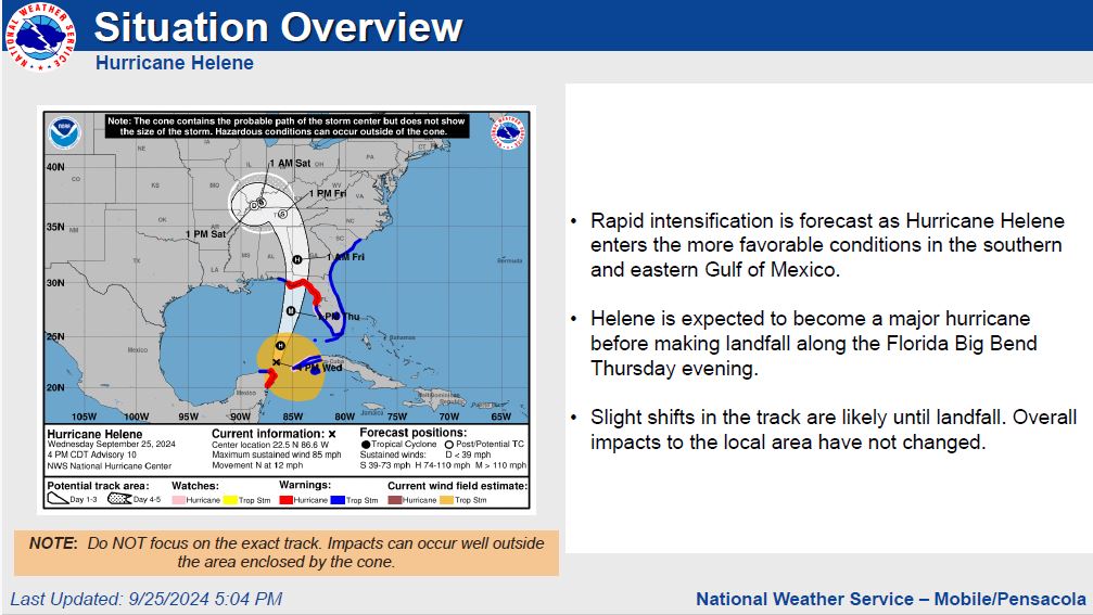
• Rapid intensification is forecast as Hurricane Helene enters the more favorable conditions in the southern and eastern Gulf of Mexico.
• Helene is expected to become a major hurricane before making landfall along the Florida Big Bend Thursday evening.
• The earliest reasonable time of arrival of Tropical Storm Force Winds is Thursday morning.
• However , the most likely time this area could see Tropical Storm Force Winds is Thursday afternoon.
Based on the latest track and guidance, the probability for storm surge inundation west of Mexico Beach is very low.
Potential Impacts:
- Tropical storm force (>=39 mph) wind speed probabilities are similar to the previous advisory.
- There is a 1 in 10 to 4 in 10 chance of tropical storm force winds across portions of south central Alabama and northwest Florida.
High Risk of deadly rip currents:
• When: Tonight through Friday Night.
Dangerously High Surf:
• When: Late tonight through Friday morning. Breakers greater than 10 feet expected late Thursday afternoon through Thursday night.
• This will likely cause over wash along the more vulnerable coastal roads.
Coastal Flood Advisory:
- Rainfall amounts of 2 to 4 inches is currently forecast across south central Alabama and the western Florida panhandle.
- Although this system will move quickly, minor river flooding may become a concern heading into this weekend.
Key Take-Aways:
For Your Awareness:
- Sand is available: located at the Baldwin County Central Annex (22251 Palmer St. Robertsdale, AL 36567). This is "self-serve". Please bring your own bags and tools if you need sand.
- Beach Flags have now upgraded to Single Red.
Preparedness Tips:
- Have multiple ways of receiving correct information from National Weather Service of Mobile, Baldwin County EMA, and your local news outlets.
- Sign up for local, emergency alerts through www.alertbaldwin.com/.
- Know your risks and potential impacts. Know your location on a map, your evacuation zone and potential evacuation routes.
- Have any necessary supplies gathered to be self-sufficient for 5 days. Don’t forget medications and pet supplies.
- Review important documents and insurance policies. Make sure you have flood insurance if needed.
- Make an emergency plan and ensure all family members know how to contact each other and where to meet in case of an evacuation.
- Steer clear of misinformation (especially on social media). Have multiple forms of receiving CORRECT information. (Baldwin County EMA, National Weather Service of Mobile, Local media outlets, etc.)
- Monitor daily beach conditions and be aware of flag warnings. For a daily beach report, text ALBEACHES to 888777.
For more information on emergency preparedness: https://baldwincountyal.gov/ema
For any media inquiries: https://baldwincountyal.gov/departments/county-administration/media-request
BCEMA and local officials are monitoring conditions and will update as any new information becomes available through National Weather Service of Mobile.
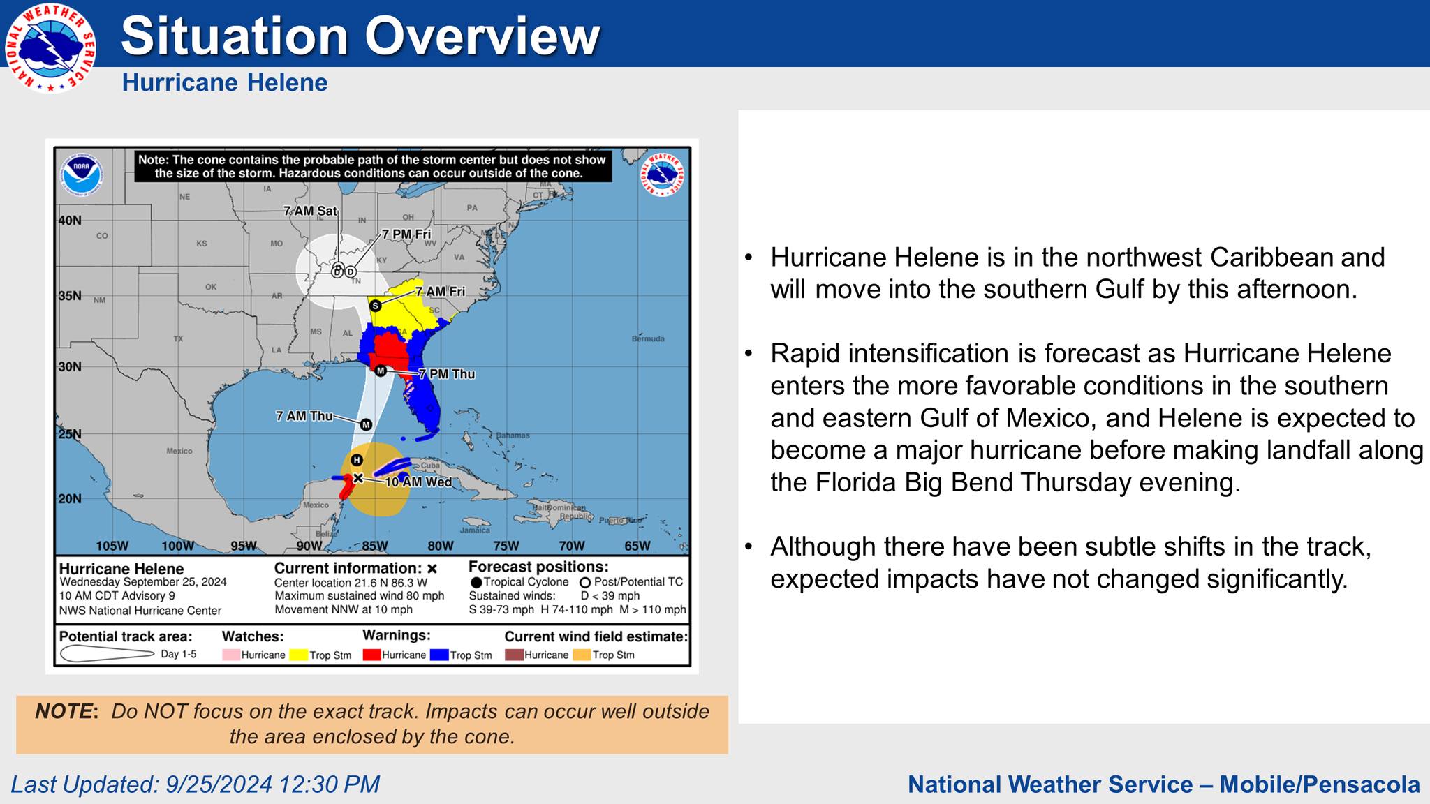
• Hurricane Helene is in the northwest Caribbean and will move into the southern Gulf by this afternoon.
• Rapid intensification is forecast as Hurricane Helene enters the more favorable conditions in the southern and eastern Gulf of Mexico, and Helene is expected to become a major hurricane before making landfall along the Florida Big Bend Thursday evening.
• The earliest reasonable time of arrival of Tropical Storm Force Winds is Thursday morning.
• However , the most likely time this area could see Tropical Storm Force Winds is Thursday afternoon.
Based on the latest track and guidance, the probability for storm surge inundation west of Mexico Beach is very low.
Potential Impacts:
- Tropical storm force (>=39 mph) wind speed probabilities are similar to the previous advisory.
- There is a 1 in 10 to 4 in 10 chance of tropical storm force winds across portions of south central Alabama and northwest Florida.
High Risk of deadly rip currents:
• When: Tonight through Friday Night.
Dangerously High Surf:
• When: Late tonight through Friday morning. Breakers greater than 10 feet expected late Thursday afternoon through Thursday night.
• This will likely cause over wash along the more vulnerable coastal roads.
• We will be also monitoring for the potential of at least minor coastal flooding for Thursday night and again on Friday night.
- Rainfall amounts of 2 to 4 inches is currently forecast across south central Alabama and the western Florida panhandle.
- Although this system will move quickly, minor river flooding may become a concern heading into this weekend.
Key Take-Aways:
For Your Awareness:
- Sand is available: located at the Baldwin County Central Annex (22251 Palmer St. Robertsdale, AL 36567). This is "self-serve". Please bring your own bags and tools if you need sand.
Preparedness Tips:
- Have multiple ways of receiving correct information from National Weather Service of Mobile, Baldwin County EMA, and your local news outlets.
- Sign up for local, emergency alerts through www.alertbaldwin.com/.
- Know your risks and potential impacts. Know your location on a map, your evacuation zone and potential evacuation routes.
- Have any necessary supplies gathered to be self-sufficient for 5 days. Don’t forget medications and pet supplies.
- Review important documents and insurance policies. Make sure you have flood insurance if needed.
- Make an emergency plan and ensure all family members know how to contact each other and where to meet in case of an evacuation.
- Steer clear of misinformation (especially on social media). Have multiple forms of receiving CORRECT information. (Baldwin County EMA, National Weather Service of Mobile, Local media outlets, etc.)
- Monitor daily beach conditions and be aware of flag warnings. For a daily beach report, text ALBEACHES to 888777.
For more information on emergency preparedness: https://baldwincountyal.gov/ema
For any media inquiries: https://baldwincountyal.gov/departments/county-administration/media-request
BCEMA and local officials are monitoring conditions and will update as any new information becomes available through National Weather Service of Mobile.
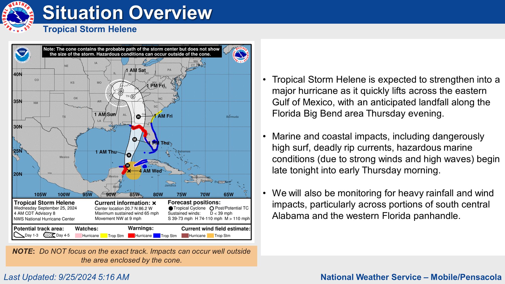
• Tropical Storm Helene is expected to strengthen into a major hurricane as it quickly lifts across the eastern Gulf of Mexico, with an anticipated landfall along the Florida Big Bend area Thursday evening.
• Marine and coastal impacts, including dangerously high surf, deadly rip currents, hazardous marine conditions (due to strong winds and high waves) begin late tonight into early Thursday morning.
• We will also be monitoring for heavy rainfall and wind impacts, particularly across portions of south central Alabama and the western Florida panhandle
• The earliest reasonable time of arrival of Tropical Storm Force Winds is Thursday morning.
• However , the most likely time this area could see Tropical Storm Force Winds is Thursday afternoon.
Based on the latest track and guidance, the probability for storm surge inundation west of Mexico Beach is very low.
Potential Impacts:
- There is a 1 in 10 to 3 in 10 chance of tropical storm force winds across portions of south central Alabama and northwest Florida.
High Risk of deadly rip currents:
• When: Tonight through Friday Night.
Dangerously High Surf:
• When: Late tonight through Friday morning. Breakers greater than 10 feet expected late Thursday afternoon through Thursday night.
• This will likely cause over wash along the more vulnerable coastal roads.
• We will be also monitoring for the potential of at least minor coastal flooding for Thursday night and again on Friday night.
- Rainfall amounts of 2 to 4 inches is currently forecast across south central Alabama and the western Florida panhandle.
- Although this system will move quickly, minor river flooding may become a concern heading into this weekend.
Key Take-Aways:
For Your Awareness:
- Sand is available: located at the Baldwin County Central Annex (22251 Palmer St. Robertsdale, AL 36567). This is "self-serve". Please bring your own bags and tools if you need sand.
Preparedness Tips:
- Have multiple ways of receiving correct information from National Weather Service of Mobile, Baldwin County EMA, and your local news outlets.
- Sign up for local, emergency alerts through www.alertbaldwin.com/.
- Know your risks and potential impacts. Know your location on a map, your evacuation zone and potential evacuation routes.
- Have any necessary supplies gathered to be self-sufficient for 5 days. Don’t forget medications and pet supplies.
- Review important documents and insurance policies. Make sure you have flood insurance if needed.
- Make an emergency plan and ensure all family members know how to contact each other and where to meet in case of an evacuation.
- Steer clear of misinformation (especially on social media). Have multiple forms of receiving CORRECT information. (Baldwin County EMA, National Weather Service of Mobile, Local media outlets, etc.)
- Monitor daily beach conditions and be aware of flag warnings. For a daily beach report, text ALBEACHES to 888777.
For more information on emergency preparedness: https://baldwincountyal.gov/ema
For any media inquiries: https://baldwincountyal.gov/departments/county-administration/media-request
BCEMA and local officials are monitoring conditions and will update as any new information becomes available through National Weather Service of Mobile.
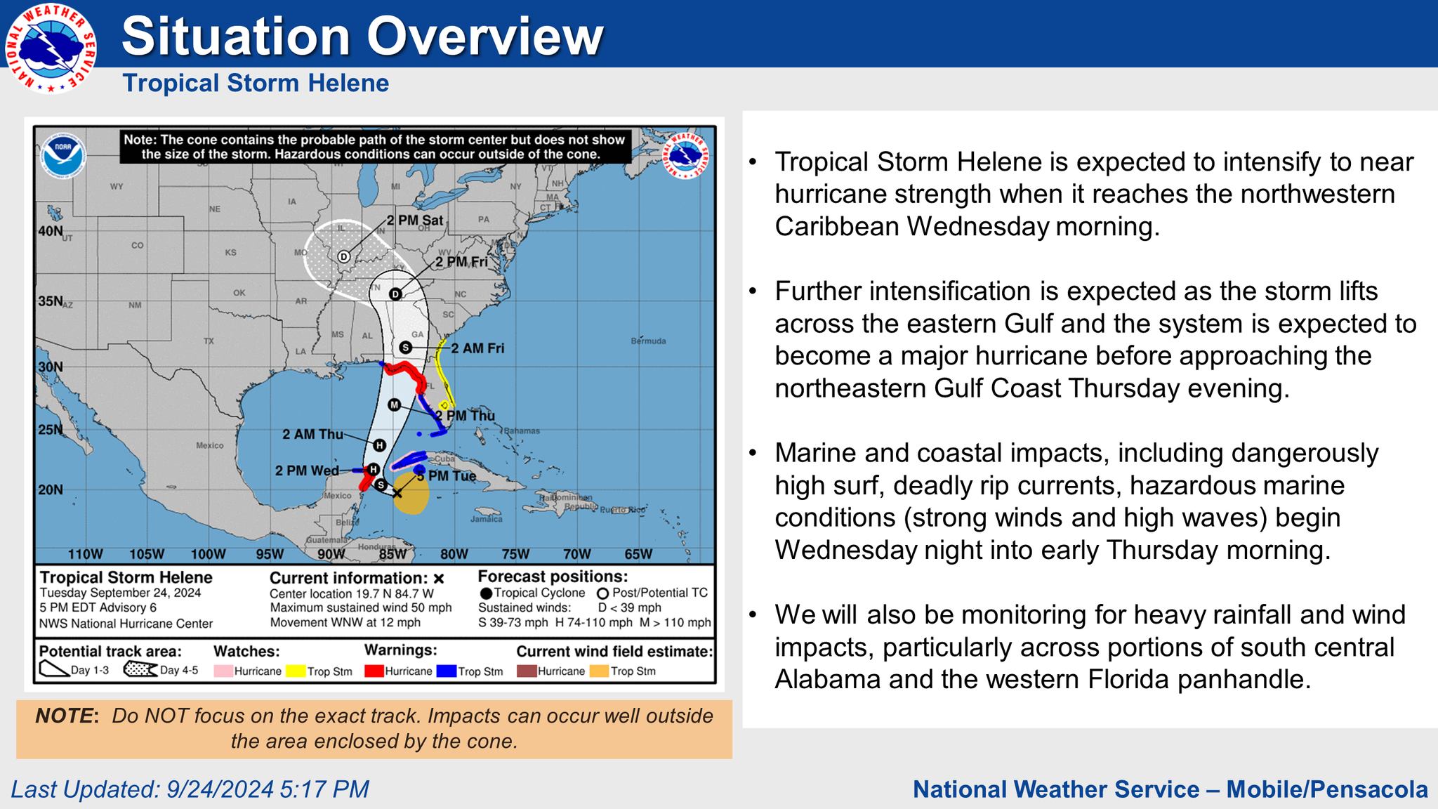
• Tropical Storm Helene is expected to intensify to near hurricane strength when it reaches the northwestern Caribbean Wednesday morning.
• Further intensification is expected as the storm lifts across the eastern Gulf and the system is expected to become a major hurricane before approaching the northeastern Gulf Coast Thursday evening.
• Marine and coastal impacts, including dangerously high surf, deadly rip currents, hazardous marine conditions (strong winds and high waves) begin Wednesday night into early Thursday morning.
• We will also be monitoring for heavy rainfall and wind impacts, particularly across portions of south central Alabama and the western Florida panhandle.
• However , the most likely time this area could see Tropical Storm Force Winds is now Thursday afternoon.
Based on the latest track and guidance, the probability for storm surge inundation west of Mexico Beach is very low.
Potential Impacts:
- Tropical storm force (>=39 mph) wind speed probabilities have decreased slightly since the previous advisory.
- There is a 1 in 10 to 2 in 10 chance across portions of south central Alabama, northwest Florida, and coastal southwest Alabama.
• Where: along the Alabama and western Florida panhandle beaches.
- We will be also monitoring for the potential of at least minor coastal flooding.
- Rainfall amounts of 2 to 5 inches is currently forecast across south central Alabama and the western Florida panhandle.
- Although this system will move quickly, minor river flooding may become a concern heading into this weekend.
Key Take-Aways:
Please see graphic for more information.
For Your Awareness:
- Sand is available: located at the Baldwin County Central Annex (22251 Palmer St. Robertsdale, AL 36567). This is "self-serve". Please bring your own bags and tools if you need sand.
Preparedness Tips:
- Have multiple ways of receiving correct information from National Weather Service of Mobile, Baldwin County EMA, and your local news outlets.
- Sign up for local, emergency alerts through www.alertbaldwin.com/.
- Know your risks and potential impacts. Know your location on a map, your evacuation zone and potential evacuation routes.
- Have any necessary supplies gathered to be self-sufficient for 5 days. Don’t forget medications and pet supplies.
- Review important documents and insurance policies. Make sure you have flood insurance if needed.
- Make an emergency plan and ensure all family members know how to contact each other and where to meet in case of an evacuation.
- Steer clear of misinformation (especially on social media). Have multiple forms of receiving CORRECT information. (Baldwin County EMA, National Weather Service of Mobile, Local media outlets, etc.)
- Monitor daily beach conditions and be aware of flag warnings. For a daily beach report, text ALBEACHES to 888777.
For more information on emergency preparedness: https://baldwincountyal.gov/ema
For any media inquiries: https://baldwincountyal.gov/departments/county-administration/media-request
BCEMA and local officials are monitoring conditions and will update as any new information becomes available through National Weather Service of Mobile.
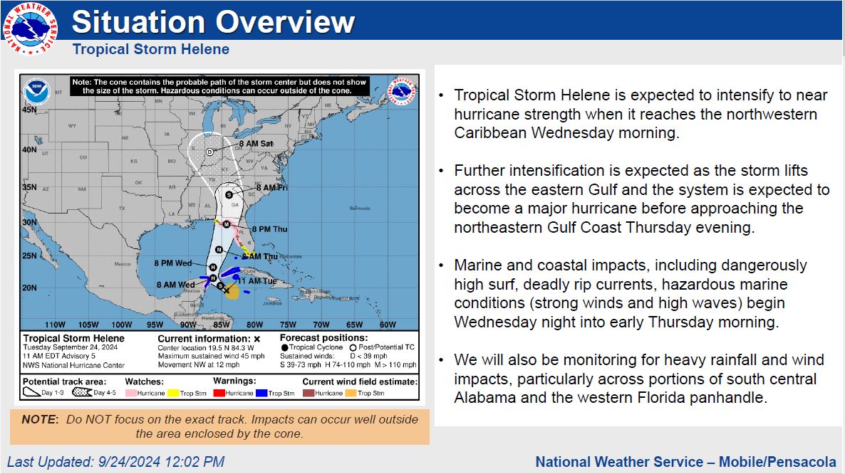
Tropical Storm Helene is expected to intensify to near hurricane strength when it reaches the northwestern Caribbean Wednesday morning.
Further intensification is expected as the storm lifts across the eastern Gulf and the system is expected to become a major hurricane before approaching the northeastern Gulf Coast Thursday evening.
Marine and coastal impacts, including dangerously high surf, deadly rip currents, hazardous marine conditions (strong winds and high waves) begin Wednesday night into early Thursday morning.
We will also be monitoring for heavy rainfall and wind impacts, particularly across portions of south central Alabama and the western Florida panhandle.
- The earliest reasonable time of arrival of Tropical Storm Force Winds is now early Thursday morning.
- However , the most likely time this area could see Tropical Storm Force Winds is now Thursday afternoon.
Based on the latest track and guidance, the probability for storm surge inundation west of Mexico Beach is very low.
Potential Impacts:
- Tropical storm force (>=39 mph) wind speed probabilities have decreased slightly since the previous advisory.
- There is a 1 in 10 to 2 in 10 chance across portions of south central Alabama, northwest Florida, and coastal southwest Alabama.
• Where: along the Alabama and western Florida panhandle beaches.
- We will be also monitoring for the potential of at least minor coastal flooding along the Alabama and western Florida panhandle coastal interface late this week, especially going into Thursday night.
- Rainfall amounts of 2 to 5 inches is currently forecast across south central Alabama and the western Florida panhandle.
- Although this system will move quickly, minor river flooding may become a concern heading into this weekend.
Key Take-Aways:
For Your Awareness:
- Sand is available: located at the Baldwin County Central Annex (22251 Palmer St. Robertsdale, AL 36567). This is "self-serve". Please bring your own bags and tools if you need sand.
Preparedness Tips:
- Have multiple ways of receiving correct information from National Weather Service of Mobile, Baldwin County EMA, and your local news outlets.
- Sign up for local, emergency alerts through www.alertbaldwin.com/.
- Know your risks and potential impacts. Know your location on a map, your evacuation zone and potential evacuation routes.
- Have any necessary supplies gathered to be self-sufficient for 5 days. Don’t forget medications and pet supplies.
- Review important documents and insurance policies. Make sure you have flood insurance if needed.
- Make an emergency plan and ensure all family members know how to contact each other and where to meet in case of an evacuation.
- Steer clear of misinformation (especially on social media). Have multiple forms of receiving CORRECT information. (Baldwin County EMA, National Weather Service of Mobile, Local media outlets, etc.)
- Monitor daily beach conditions and be aware of flag warnings. For a daily beach report, text ALBEACHES to 888777.
For more information on emergency preparedness: https://baldwincountyal.gov/ema
For any media inquiries: https://baldwincountyal.gov/departments/county-administration/media-request
BCEMA and local officials are monitoring conditions and will update as any new information becomes available through National Weather Service of Mobile.
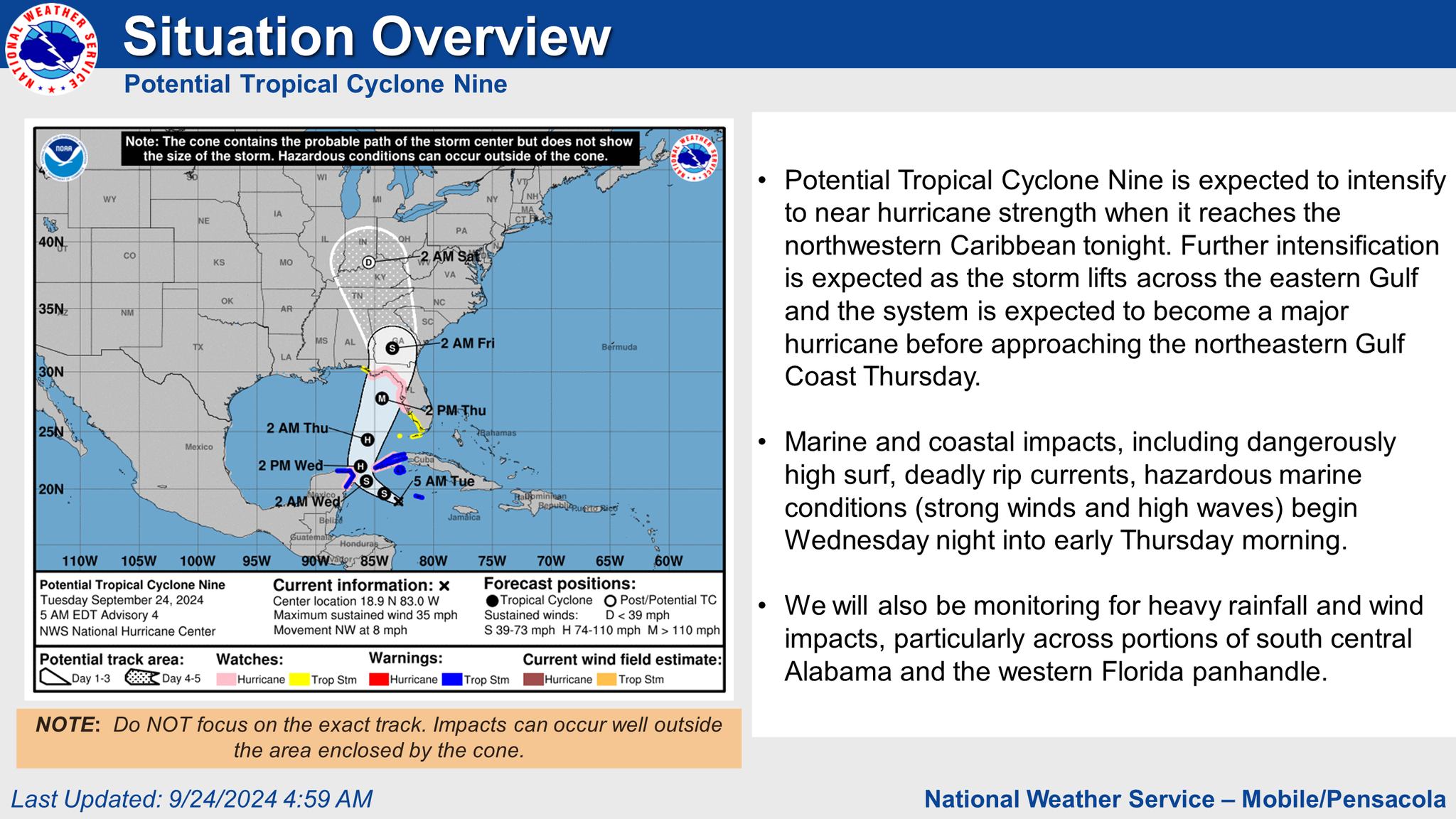
Potential Tropical Cyclone Nine is expected to intensify to near hurricane strength when it reaches the northwestern Caribbean tonight. Further intensification is expected as the storm lifts across the eastern Gulf and the system is expected to become a major hurricane before approaching the northeastern Gulf Coast Thursday.
- The earliest reasonable time of arrival of Tropical Storm Force Winds is late Wednesday night.
- However , the most likely time this area could see Tropical Storm Force Winds is Thursday morning.
Cyclone Nine, and it is too soon to let your guard down.
Potential Impacts:
- Tropical storm force (>=39 mph) wind speed probabilities have decreased slightly since the previous advisory.
- There is a 1 in 10 to 2 in 10 chance across portions of south central Alabama, northwest Florida, and coastal southwest Alabama.
- A High Risk of deadly rip currents will begin Wednesday night and continue through the end of the week along the Alabama and western Florida panhandle beaches.
- Dangerous high surf will also build along the Alabama and western Florida panhandle beaches as soon as Wednesday night with breakers over 10 feet possible late Thursday afternoon into Thursday night.
- We will be also monitoring for the potential of at least minor coastal flooding along the Alabama and western Florida panhandle coastal interface late this week, especially going into Thursday night.
- Rainfall amounts of 2 to 5 inches is currently forecast across south central Alabama and the western Florida panhandle.
- Although this system will move quickly, minor river flooding may become a concern heading into this weekend.
Key Take-Aways:
PTC9 is expected to intensify into a major hurricane before it approaches the northeastern Gulf Coast on Thursday.
What We Know:
Please see graphic for more information.
For Your Awareness:
- Sand is available: located at the Baldwin County Central Annex (22251 Palmer St. Robertsdale, AL 36567). This is "self-serve". Please bring your own bags and tools if you need sand.
Preparedness Tips:
- Have multiple ways of receiving correct information from National Weather Service of Mobile, Baldwin County EMA, and your local news outlets.
- Sign up for local, emergency alerts through www.alertbaldwin.com/.
- Know your risks and potential impacts. Know your location on a map, your evacuation zone and potential evacuation routes.
- Have any necessary supplies gathered to be self-sufficient for 5 days. Don’t forget medications and pet supplies.
- Review important documents and insurance policies. Make sure you have flood insurance if needed.
- Make an emergency plan and ensure all family members know how to contact each other and where to meet in case of an evacuation.
- Steer clear of misinformation (especially on social media). Have multiple forms of receiving CORRECT information. (Baldwin County EMA, National Weather Service of Mobile, Local media outlets, etc.)
- Monitor daily beach conditions and be aware of flag warnings. For a daily beach report, text ALBEACHES to 888777.
For more information on emergency preparedness: https://baldwincountyal.gov/ema
For any media inquiries: https://baldwincountyal.gov/departments/county-administration/media-request
BCEMA and local officials are monitoring conditions and will update as any new information becomes available through National Weather Service of Mobile.
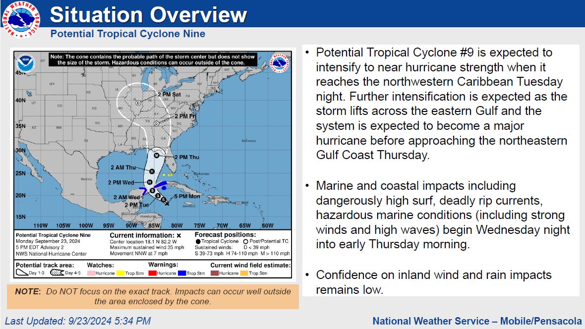
Potential Tropical Cyclone #9 is expected to intensify to near hurricane strength when it reaches the northwestern Caribbean Tuesday night. Further intensification is expected as the storm lifts across the eastern Gulf and the system is expected to become a major hurricane before approaching the northeastern Gulf Coast Thursday.
- The earliest reasonable time of arrival of Tropical Storm Force Winds is late Wednesday night.
- However , the most likely time this area could see Tropical Storm Force Winds is Thursday morning.
Cyclone Nine, and it is too soon to let your guard down.
Potential Impacts:
- Rainfall amounts of 2 to 5 inches is currently forecast across southwest and south central Alabama and the western Florida panhandle.
- Although this system will move quickly, minor river flooding may become a concern heading into this weekend.
- Tropical storm force (>=39 mph) wind speed probabilities have increased to a 2 in 10 to 3 in 10 chance across portions of south central Alabama, northwest Florida, and coastal southwest Alabama.
- A High Risk of deadly rip currents will begin Wednesday night and continue through the end of the week along the Alabama and western Florida panhandle beaches.
- Dangerous high surf will also build along the Alabama and western Florida panhandle beaches as soon as Wednesday night with breakers over 10 feet possible late Thursday afternoon into Thursday night.
- We will be also monitoring for the potential of at least minor coastal flooding along the Alabama and western Florida panhandle coastal interface late this week, especially around times of high tide Thursday night and Friday morning.
Key Take-Aways:
– PTC9 will be moving into a very favorable environment for further strengthening and a major hurricane appears plausible.
– This system will have a large wind field and impacts WILL be felt well outside of the cone .
conditions (strong winds and high waves).
Please see graphic for more information.
For Your Awareness:
- Sand is available: located at the Baldwin County Central Annex (22251 Palmer St. Robertsdale, AL 36567). This is "self-serve". Please bring your own bags and tools if you need sand.
Preparedness Tips:
- Have multiple ways of receiving correct information from National Weather Service of Mobile, Baldwin County EMA, and your local news outlets.
- Sign up for local, emergency alerts through www.alertbaldwin.com/.
- Know your risks and potential impacts. Know your location on a map, your evacuation zone and potential evacuation routes.
- Have any necessary supplies gathered to be self-sufficient for 5 days. Don’t forget medications and pet supplies.
- Review important documents and insurance policies. Make sure you have flood insurance if needed.
- Make an emergency plan and ensure all family members know how to contact each other and where to meet in case of an evacuation.
- Steer clear of misinformation (especially on social media). Have multiple forms of receiving CORRECT information. (Baldwin County EMA, National Weather Service of Mobile, Local media outlets, etc.)
- Monitor daily beach conditions and be aware of flag warnings. For a daily beach report, text ALBEACHES to 888777.
For more information on emergency preparedness: https://baldwincountyal.gov/ema
For any media inquiries: https://baldwincountyal.gov/departments/county-administration/media-request
BCEMA and local officials are monitoring conditions and will update as any new information becomes available through National Weather Service of Mobile.
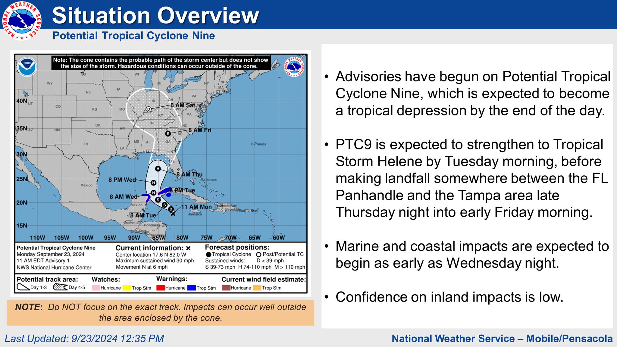
- However , the most likely time this area could see Tropical Storm Force Winds is Thursday morning.
Please see graphic for more information.
For Your Awareness:
- Sand is available: located at the Baldwin County Central Annex (22251 Palmer St. Robertsdale, AL 36567). This is "self-serve". Please bring your own bags and tools if you need sand.
Preparedness Tips:
- Have multiple ways of receiving correct information from National Weather Service of Mobile, Baldwin County EMA, and your local news outlets.
- Sign up for local, emergency alerts through www.alertbaldwin.com/.
- Know your risks and potential impacts. Know your location on a map, your evacuation zone and potential evacuation routes.
- Have any necessary supplies gathered to be self-sufficient for 5 days. Don’t forget medications and pet supplies.
- Review important documents and insurance policies. Make sure you have flood insurance if needed.
- Make an emergency plan and ensure all family members know how to contact each other and where to meet in case of an evacuation.
- Steer clear of misinformation (especially on social media). Have multiple forms of receiving CORRECT information. (Baldwin County EMA, National Weather Service of Mobile, Local media outlets, etc.)
- Monitor daily beach conditions and be aware of flag warnings. For a daily beach report, text ALBEACHES to 888777.
For more information on emergency preparedness: https://baldwincountyal.gov/ema
For any media inquiries: https://baldwincountyal.gov/departments/county-administration/media-request
BCEMA and local officials are monitoring conditions and will update as any new information becomes available through National Weather Service of Mobile.
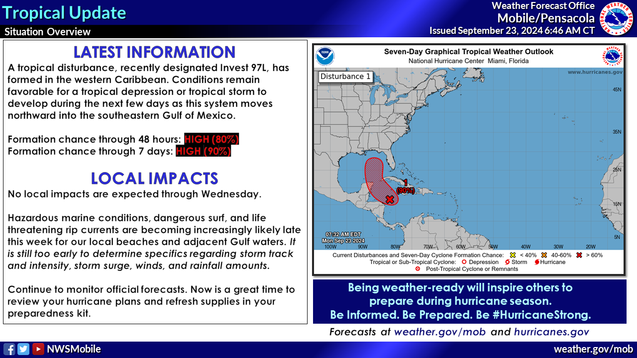
Baldwin County Emergency Management Agency is encouraging residents and visitors of Baldwin County to monitor local weather and be prepared should we have direct impacts to our area. Now is a good time to review your plans and replenish any necessary supplies.
Tropical Update:
OVERVIEW: A tropical disturbance, which recently became designated Invest 97L, has developed in the western Caribbean. Conditions remain favorable for tropical development as this system lifts into the northwest Caribbean and Gulf of Mexico this week. NHC has increased the chance of development to 80 percent over the next 48 hours and 90 percent over the next seven days.
WHAT WE KNOW: Confidence continues to increase that Invest 97L will develop into a tropical depression or storm as it lifts northward into the Gulf of Mexico within the next few days. Further strengthening into a hurricane is possible. Confidence also continues to increase that hazardous marine conditions, dangerous surf, and life-threatening rip currents will impact our local beaches and adjacent Gulf waters by Thursday in association with this system.
WHAT WE DON'T KNOW YET: It is still too early to determine eventual intensity, track, or specific locations in the path of this system at this time, as these details will be difficult to resolve until the system organizes with a well-defined circulation. Rainfall amounts, wind, and the magnitude of storm surge potential in our area will ultimately be dependent on the track of the storm.
Key Take-Aways
- No local impacts are expected through Wednesday.
- The developing system is expected to enter the southern Gulf of Mexico midweek and quickly lift northward toward the northeastern Gulf Coast later this week. It is still too early to determine eventual intensity and specific locations in the path of this system currently
- Regardless of track, we are becoming increasingly confident that marine and surf conditions will deteriorate starting Thursday as the system moves into the northern Gulf. Rapidly building wave heights, very high surf, and life-threatening rip currents can be expected late this week.
- While impacts from heavy rainfall, wind, and storm surge will be possible by late this week, it is still too early to speak on specifics as these impacts will be dependent on the eventual track of the storm.
- Now is a great time to review hurricane preparedness and refresh supplies in preparedness kits.
Please see graphic for more information.
For Your Awareness:
- Sand is available: located at the Baldwin County Central Annex (22251 Palmer St. Robertsdale, AL 36567). This is "self-serve". Please bring your own bags and tools if you need sand.
Preparedness Tips:
- Have multiple ways of receiving correct information from National Weather Service of Mobile, Baldwin County EMA, and your local news outlets.
- Sign up for local, emergency alerts through www.alertbaldwin.com/.
- Know your risks and potential impacts. Know your location on a map, your evacuation zone and potential evacuation routes.
- Have any necessary supplies gathered to be self-sufficient for 5 days. Don’t forget medications and pet supplies.
- Review important documents and insurance policies. Make sure you have flood insurance if needed.
- Make an emergency plan and ensure all family members know how to contact each other and where to meet in case of an evacuation.
- Steer clear of misinformation (especially on social media). Have multiple forms of receiving CORRECT information. (Baldwin County EMA, National Weather Service of Mobile, Local media outlets, etc.)
- Monitor daily beach conditions and be aware of flag warnings. For a daily beach report, text ALBEACHES to 888777.
For more information on emergency preparedness: https://baldwincountyal.gov/ema
For any media inquiries: https://baldwincountyal.gov/departments/county-administration/media-request
BCEMA and local officials are monitoring conditions and will update as any new information becomes available through National Weather Service of Mobile.

Contact Baldwin County Citizen Service Center
251.580.1695
Email Citizen Services
Baldwin County Commission Facility Closures
Email Webmaster for Web Inquiry
Baldwin County Commission Accessibility Statement
2020 Baldwin County Commission, Alabama. All rights reserved.
Powered by BCC CIS